File:Antarctica Without Ice Sheet.png

Ifayela ewu ngqo (782 × 1,000 pixels, file size: 675 KB, MIME type: image/png)
Isifinyezo
| Incazelo |
Русский: Рельеф Антарктиды с учетом поднятия земной коры после таяния ледников и повышения уровня океана
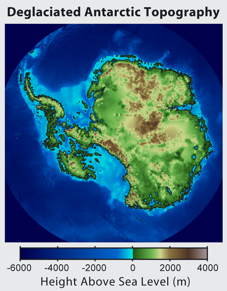
English: This is topographic map of Antarctica after removing the ice sheet and accounting for both isostatic rebound and sea level rise. Hence this map suggests what Antarctica may have looked like 35 million years ago, when the Earth was warm enough to prevent the formation of large-scale ice sheets in Antarctica.
Isostatic rebound is the result of the weight of the ice sheet depressing the land under it. After the ice is removed, the land will rise over a period of thousands of years by an amount approximately 1/3 as high as the ice sheet that was removed (because rock is 3 times as dense as ice). Approximately half the uplift occurs during the first two thousand years. If the ice sheet is removed over more than a few thousand years, then it is possible that a majority of the uplift will occur before the ice sheet fully disappears. As indicated in the map, Antarctica consists of a large continental region (East Antarctica) and group of seas and smaller land regions (West Antarctica). Since the West Antarctic ice sheet is partially anchored below sea level, this region is less stable and more likely to be affected by global warming. Even so, it is likely that during the next century increased precipitation over Antarctica will offset melting. Even in the event of severe sustained warming, it would take many thousands of years for Eastern Antarctica to be fully deglaciated.Français : Carte topographique de l'Antarctique après avoir retirer la couche de glace et pris en compte le rebond isostatique ainsi que la montée du niveau de la mer Par conséquent cette carte montre ce à quoi l'Antarctique aurait pu ressembler il y a 35 millions d'années, quand la Terre était suffisament chause pour prévenir la formation d'une importante calotte glaciaire en Antarctique.
Le rebond isostatique est la conséquence de la couche de glace qui fait pression sur le sol et crée des dépressions. Après le retrait de la glace, le sol s'élève sur une période de milliers d'années par un rythme correspondant à un tiers de la hauteur de la couche de glace qui fut retirée (car la roche est trois fois plus dense que la glace). La moitié de l'élévation se fait pendant les deux premiers milliers d'années. Si la glace se retire sur une période dépassant plusieurs milliers d'année, il est possible que le rebond ait lieu avant que la couche de glace ne disparaisse complètement. Comme montré sur la carte, l'Antarctique est composé d'une large région continentale (Antarctique oriental) et d'un groupe de mers et de petites régions terrestres (Antarctique occidental). Puisque la plaque glaciaire de l'Arctique occidental est en partie en dessous du niveau de la mer, cette région est moins stable et plus susceptible d'être affectée par le réchauffement climatique. En dépit de cela, des précipitation en Antarctique peuvent compenser la fonte. La fonte de l'Antarctique oriental prendra plusieurs milliers d'années, même en cas de réchauffement sévère et continu. |
| Usuku | |
| Umthombo | http://www.globalwarmingart.com/wiki/File:Antarctica_Without_Ice_Sheet_png |
| Umlobi | Image created by Robert A. Rohde / Global Warming Art |
| Other versions | File:Deglaciated Antarctic Topography.png – with no description (internationalized) |
Licensing

|
Permission is granted to copy, distribute and/or modify this document under the terms of the GNU Free Documentation License, Version 1.2 or any later version published by the Free Software Foundation; with no Invariant Sections, no Front-Cover Texts, and no Back-Cover Texts. A copy of the license is included in the section entitled GNU Free Documentation License. |
- Ukhululekile:
- ukwabelana – to copy, distribute and transmit the work
- to remix – to adapt the work
- Ngaphansi kwezimo ezilandelayo:
- attribution – You must give appropriate credit, provide a link to the license, and indicate if changes were made. You may do so in any reasonable manner, but not in any way that suggests the licensor endorses you or your use.
- yabelana ngokufana – If you remix, transform, or build upon the material, you must distribute your contributions under the same or compatible license as the original.
Umlando womqulu
Click on a date/time to view the file as it appeared at that time.
| Usuku/Isikhathi | Isithonjana | Dimensions | Umsebenzisi | Amazwana | |
|---|---|---|---|---|---|
| Njengamanje | 16:56, 16 uNhlangulana 2015 | | 782 × 1,000 (675 KB) | Szczureq | larger image |
| 05:57, 10 uMfumfu 2012 |  | 469 × 600 (316 KB) | Strannik27 | User created page with UploadWizard |
Ukusetshenziswa komqulu
The following page uses this file:
Ukusetshenziswa komqulu jikelele
Amanye ama-wiki asebenzisa lefayela
- Ukusetshenziswa ku-ar.wikipedia.org
- Ukusetshenziswa ku-ast.wikipedia.org
- Ukusetshenziswa ku-ban.wikipedia.org
- Ukusetshenziswa ku-ba.wikipedia.org
- Ukusetshenziswa ku-be-tarask.wikipedia.org
- Ukusetshenziswa ku-be.wikipedia.org
- Ukusetshenziswa ku-br.wikipedia.org
- Ukusetshenziswa ku-bxr.wikipedia.org
- Ukusetshenziswa ku-ca.wikipedia.org
- Ukusetshenziswa ku-cs.wikipedia.org
- Ukusetshenziswa ku-de.wikipedia.org
- Ukusetshenziswa ku-en.wikipedia.org
- Ukusetshenziswa ku-es.wikipedia.org
- Ukusetshenziswa ku-es.wikibooks.org
- Ukusetshenziswa ku-fr.wikipedia.org
- Ukusetshenziswa ku-id.wikipedia.org
- Ukusetshenziswa ku-it.wikipedia.org
- Ukusetshenziswa ku-ja.wikipedia.org
- Ukusetshenziswa ku-ka.wikipedia.org
- Ukusetshenziswa ku-kn.wikipedia.org
- Ukusetshenziswa ku-la.wikipedia.org
- Ukusetshenziswa ku-mn.wikipedia.org
- Ukusetshenziswa ku-nl.wikipedia.org
- Ukusetshenziswa ku-no.wikipedia.org
- Ukusetshenziswa ku-pl.wikipedia.org
- Ukusetshenziswa ku-ru.wikipedia.org
- Ukusetshenziswa ku-tg.wikipedia.org
- Ukusetshenziswa ku-tr.wikipedia.org
- Ukusetshenziswa ku-uk.wikipedia.org
- Ukusetshenziswa ku-zh.wikipedia.org