File:Djibouti relief location map.jpg

Size of this preview: Amachashazikazi ama-599 adlulayo nama-600 amile. Other resolutions: Amachashazikazi ama-240 adlulayo nama-240 amile | Amachashazikazi ama-479 adlulayo nama-480 amile | Amachashazikazi ama-767 adlulayo nama-768 amile | Amachashazikazi ama-1,023 adlulayo nama-1,024 amile | Amachashazikazi ama-1,540 adlulayo nama-1,542 amile.
Ifayela ewu ngqo (1,540 × 1,542 pixels, file size: 1.26 MB, MIME type: image/jpeg)
| Incazelo |
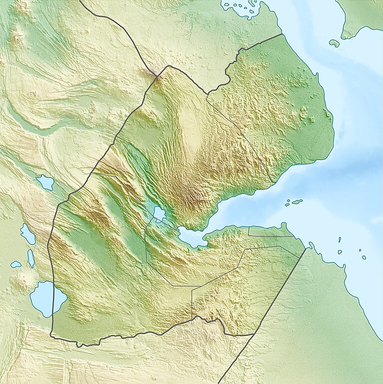
Deutsch: Physische Positionskarte von Dschibuti
Quadratische Plattkarte. Geographische Begrenzung der Karte:
English: Physical location map of Djibouti
Equirectangular projection. Geographic limits of the map:
|
| Usuku | |
| Umthombo | Own work, using map data from administrative map by NordNordWest. The relief was created from SRTM-3 relief data |
| Umlobi | Carport |
| Permission (Reusing this file) |
This file is licensed under the Creative Commons Attribution-Share Alike 3.0 Unported license.
|
| Other versions |
|

Umlando womqulu
Click on a date/time to view the file as it appeared at that time.
| Usuku/Isikhathi | Isithonjana | Dimensions | Umsebenzisi | Amazwana | |
|---|---|---|---|---|---|
| Njengamanje | 08:53, 17 uMbasa 2010 | | 1,540 × 1,542 (1.26 MB) | Carport | {{Information |Description={{de|Physische Positionskarte von {{w|Dschibuti|3=de}}}} Quadratische Plattkarte. Geographische Begrenzung der Karte: * N: 12.9° N * S: 10.7° N * W: 41.5° O * O: 43.7° O {{en|Physical location map of {{w|Djibouti}}}} Equirec |
Ukusetshenziswa komqulu
The following page uses this file:
Ukusetshenziswa komqulu jikelele
Amanye ama-wiki asebenzisa lefayela
- Ukusetshenziswa ku-ar.wikipedia.org
- Ukusetshenziswa ku-ast.wikipedia.org
- Ukusetshenziswa ku-az.wikipedia.org
- Ukusetshenziswa ku-ba.wikipedia.org
- Ukusetshenziswa ku-be.wikipedia.org
- Ukusetshenziswa ku-bg.wikipedia.org
- Ukusetshenziswa ku-bn.wikipedia.org
- Ukusetshenziswa ku-bs.wikipedia.org
- Ukusetshenziswa ku-ceb.wikipedia.org
- Ukusetshenziswa ku-ce.wikipedia.org
- Ukusetshenziswa ku-ckb.wikipedia.org
- Ukusetshenziswa ku-cs.wikipedia.org
- Ukusetshenziswa ku-da.wikipedia.org
- Ukusetshenziswa ku-de.wikipedia.org
- Dschibuti
- Assalsee (Dschibuti)
- Abbe-See
- Arta (Dschibuti)
- Golf von Tadjoura
- Vorlage:Positionskarte Dschibuti
- Wikipedia:Kartenwerkstatt/Positionskarten/Afrika
- Ardoukoba
- Benutzer:Carport/Galerie
- Holhol
- Ali Adde
- Loyada
- Goda-Massiv
- Mousa Alli
- Doumeira
- Musha (Insel)
- Sawabi-Inseln
- Oueah
- Ghoubbet-el-Kharab
- Damerjog
- Musha-Inseln
- Maskal
View more global usage of this file.