File:Libyan Shabiat 2007 with numbers.svg

Size of this PNG preview of this SVG file: Amachashazikazi ama-622 adlulayo nama-599 amile. Other resolutions: Amachashazikazi ama-249 adlulayo nama-240 amile | Amachashazikazi ama-498 adlulayo nama-480 amile | Amachashazikazi ama-797 adlulayo nama-768 amile | Amachashazikazi ama-1,063 adlulayo nama-1,024 amile | Amachashazikazi ama-2,126 adlulayo nama-2,048 amile | Amachashazikazi ama-1,900 adlulayo nama-1,830 amile.
Ifayela ewu ngqo (SVG file, nominally 1,900 × 1,830 pixels, file size: 140 KB)
Isifinyezo
| Incazelo |
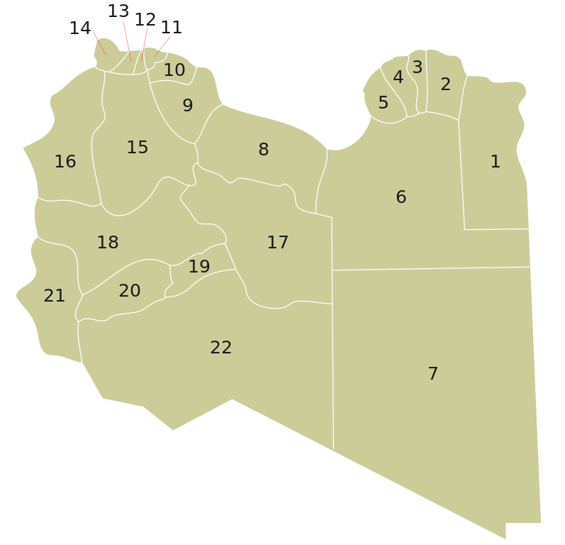
English: Map of the current twenty-two Shabiyah or Districts of Libya, established in 2007. See also: Subdivisions of Libya.
Русский: Административное деление Ливии, введённое в 2007 году. |
| Usuku | |
| Umthombo | Own work |
| Umlobi | Maxrossomachin |
| Other versions |
Derivative works of this file: |
Licensing
| I, the copyright holder of this work, release this work into the public domain. This applies worldwide. In some countries this may not be legally possible; if so: I grant anyone the right to use this work for any purpose, without any conditions, unless such conditions are required by law. |
Umlando womqulu
Click on a date/time to view the file as it appeared at that time.
| Usuku/Isikhathi | Isithonjana | Dimensions | Umsebenzisi | Amazwana | |
|---|---|---|---|---|---|
| Njengamanje | 08:57, 20 uLwezi 2012 | | 1,900 × 1,830 (140 KB) | Kashmiri | Reverted to version as of 16:39, 1 August 2010: Display problems of the new version in the article |
| 16:28, 15 uLwezi 2012 |  | 504 × 513 (34 KB) | Kashmiri | Unused image parts removed; resized to 500px | |
| 16:39, 1 uNcwaba 2010 |  | 1,900 × 1,830 (140 KB) | Maxrossomachin | {{Information |Description={{en|1=Numbered Lybian Municipalities as of 2007}} {{ru|1=Административное деление Ливии, введённое в 2007 году.}} |Source={{own}} |Author=Maxrossomachin |Date=20 |
Ukusetshenziswa komqulu
The following page uses this file:
Ukusetshenziswa komqulu jikelele
Amanye ama-wiki asebenzisa lefayela
- Ukusetshenziswa ku-ab.wikipedia.org
- Ukusetshenziswa ku-ar.wikipedia.org
- Ukusetshenziswa ku-ast.wikipedia.org
- Ukusetshenziswa ku-az.wikipedia.org
- Ukusetshenziswa ku-be-tarask.wikipedia.org
- Ukusetshenziswa ku-bs.wikipedia.org
- Ukusetshenziswa ku-ca.wikipedia.org
- Ukusetshenziswa ku-ce.wikipedia.org
- Ukusetshenziswa ku-cs.wikipedia.org
- Ukusetshenziswa ku-de.wikipedia.org
- Ukusetshenziswa ku-en.wikipedia.org
- Ukusetshenziswa ku-eo.wikipedia.org
- Ukusetshenziswa ku-es.wikipedia.org
- Ukusetshenziswa ku-fi.wikipedia.org
- Ukusetshenziswa ku-frr.wikipedia.org
- Ukusetshenziswa ku-fr.wikipedia.org
- Ukusetshenziswa ku-gl.wikipedia.org
- Ukusetshenziswa ku-he.wikipedia.org
- Ukusetshenziswa ku-hr.wikipedia.org
- Ukusetshenziswa ku-hu.wikipedia.org
- Ukusetshenziswa ku-id.wikipedia.org
- Ukusetshenziswa ku-it.wikipedia.org
- Ukusetshenziswa ku-ja.wikipedia.org
- Ukusetshenziswa ku-ka.wikipedia.org
- Ukusetshenziswa ku-ko.wikipedia.org
- Ukusetshenziswa ku-lt.wikipedia.org
- Ukusetshenziswa ku-mk.wikipedia.org
- Ukusetshenziswa ku-ml.wikipedia.org
- Ukusetshenziswa ku-nl.wikipedia.org
- Ukusetshenziswa ku-pa.wikipedia.org
- Ukusetshenziswa ku-pl.wikipedia.org
- Ukusetshenziswa ku-ro.wikipedia.org
- Ukusetshenziswa ku-ru.wikipedia.org
- Ukusetshenziswa ku-sco.wikipedia.org
- Ukusetshenziswa ku-sh.wikipedia.org
- Ukusetshenziswa ku-simple.wikipedia.org
- Ukusetshenziswa ku-sr.wikipedia.org
- Ukusetshenziswa ku-sv.wikipedia.org
- Ukusetshenziswa ku-th.wikipedia.org
- Ukusetshenziswa ku-trv.wikipedia.org
- Ukusetshenziswa ku-tr.wikipedia.org
View more global usage of this file.