File:Map of South Africa with Vhembe highlighted (2011).svg

Size of this PNG preview of this SVG file: Amachashazikazi ama-684 adlulayo nama-599 amile. Other resolutions: Amachashazikazi ama-274 adlulayo nama-240 amile | Amachashazikazi ama-548 adlulayo nama-480 amile | Amachashazikazi ama-876 adlulayo nama-768 amile | Amachashazikazi ama-1,168 adlulayo nama-1,024 amile | Amachashazikazi ama-2,337 adlulayo nama-2,048 amile | Amachashazikazi ama-809 adlulayo nama-709 amile.
Ifayela ewu ngqo (SVG file, nominally 809 × 709 pixels, file size: 482 KB)
.svg)
Isifinyezo
| Incazelo |
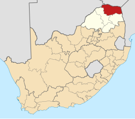
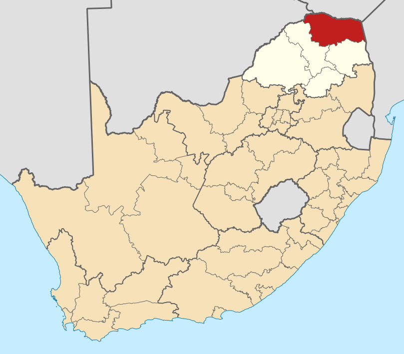
English: Map of district boundaries in South Africa, as they will be after the municipal elections of 18 May 2011, with the Vhembe District Municipality highlighted in red within Limpopo in yellow. |
| Usuku | |
| Umthombo | Own work |
| Umlobi | Htonl |
Licensing
I, the copyright holder of this work, hereby publish it under the following licenses:

|
Permission is granted to copy, distribute and/or modify this document under the terms of the GNU Free Documentation License, Version 1.2 or any later version published by the Free Software Foundation; with no Invariant Sections, no Front-Cover Texts, and no Back-Cover Texts. A copy of the license is included in the section entitled GNU Free Documentation License. |
This file is licensed under the Creative Commons Attribution-Share Alike 4.0 International, 3.0 Unported, 2.5 Generic, 2.0 Generic and 1.0 Generic license.
- Ukhululekile:
- ukwabelana – to copy, distribute and transmit the work
- to remix – to adapt the work
- Ngaphansi kwezimo ezilandelayo:
- attribution – You must give appropriate credit, provide a link to the license, and indicate if changes were made. You may do so in any reasonable manner, but not in any way that suggests the licensor endorses you or your use.
- yabelana ngokufana – If you remix, transform, or build upon the material, you must distribute your contributions under the same or compatible license as the original.
You may select the license of your choice.
Umlando womqulu
Click on a date/time to view the file as it appeared at that time.
| Usuku/Isikhathi | Isithonjana | Dimensions | Umsebenzisi | Amazwana | |
|---|---|---|---|---|---|
| Njengamanje | 00:59, 14 uNhlaba 2011 | | 809 × 709 (482 KB) | Htonl | == Summary == {{Information |Description ={{en|1=Map of district boundaries in South Africa, as they will be after the municipal elections of 18 May 2011, with the w:Vhembe District Municipality highlig |
Ukusetshenziswa komqulu
The following 2 pages use this file:
Ukusetshenziswa komqulu jikelele
Amanye ama-wiki asebenzisa lefayela
- Ukusetshenziswa ku-af.wikipedia.org
- Louis Trichardt, Limpopo
- Musina
- Thohoyandou
- Beitbrug
- Buysdorp
- Tshipise (dorpie)
- Sjabloonbespreking:Suid-Afrikaanse distriksmunisipaliteit navbox
- Olifantshoek, Limpopo
- Waterval, Limpopo
- Valdezia
- Kranspoort
- Laatsgevonden
- Levubu
- Bungeni
- Bandelierkop
- Hlanganani, Limpopo
- Dzanani
- Honingfontein
- Tiyani
- Tshitale
- Tshikota
- Vuwani
- Nyavani
- Shigalo
- Sibasa
- Makwarela
- Makumeke
- Maranzhe
- Lwamondo
- Green Farm, Limpopo
- Duthuni
- Malamulele
- Mutale
- Shakadza
- Malale
- Madimbo
- Mopane
- Basani
- Dopeni
- Dzwerani
- Gaba
- Gandlanani
- Gondeni A
- Hasane
- Hatshisele
- Itsani
- Ha-Lambani
- Jimmy Jones, Limpopo
- Jerome, Limpopo
- Jilongo
View more global usage of this file.
.svg)
.svg)