File:Sangha districts.png

Ifayela ewu ngqo (1,056 × 816 pixels, file size: 25 KB, MIME type: image/png)
Isifinyezo
| Incazelo |
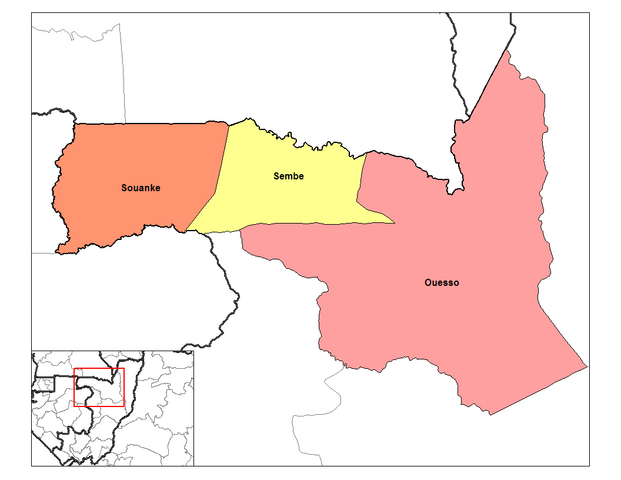
English: Map of the districts of the Sangha Department — in the western Republic of the Congo.
|
| Usuku | 12 uMandulo 2006 (original upload date) |
| Umthombo | Own work |
| Umlobi | Rarelibra at i-English Wikipedia |
Licensing
| This work has been released into the public domain by its author, Rarelibra at i-English Wikipedia. This applies worldwide. In some countries this may not be legally possible; if so: Rarelibra grants anyone the right to use this work for any purpose, without any conditions, unless such conditions are required by law. |
Original upload log
The original description page was here. All following user names refer to en.wikipedia.
- 2006-09-12 15:15 Rarelibra 1056×816 (25343 bytes) Map of the districts of Sangha region in the Republic of the Congo. Created by ~~~~ for public domain use, using MapInfo Professional v8.5 and various mapping resources.
Umlando womqulu
Click on a date/time to view the file as it appeared at that time.
| Usuku/Isikhathi | Isithonjana | Dimensions | Umsebenzisi | Amazwana | |
|---|---|---|---|---|---|
| Njengamanje | 15:39, 29 uMasingana 2012 | | 1,056 × 816 (25 KB) | BotMultichillT | {{BotMoveToCommons|en.wikipedia|year={{subst:CURRENTYEAR}}|month={{subst:CURRENTMONTHNAME}}|day={{subst:CURRENTDAY}}}} == {{int:filedesc}} == {{Information |description={{en|1=Map of the districts of Sangha region in the Republic of the Congo. Created by |
Ukusetshenziswa komqulu
The following 4 pages use this file:
Ukusetshenziswa komqulu jikelele
Amanye ama-wiki asebenzisa lefayela
- Ukusetshenziswa ku-en.wikipedia.org
- Ukusetshenziswa ku-es.wikipedia.org
- Ukusetshenziswa ku-ha.wikipedia.org
- Ukusetshenziswa ku-ig.wikipedia.org
- Ukusetshenziswa ku-it.wikipedia.org
- Ukusetshenziswa ku-lt.wikipedia.org
- Ukusetshenziswa ku-ru.wikipedia.org
- Ukusetshenziswa ku-sw.wikipedia.org
- Ukusetshenziswa ku-tr.wikipedia.org
- Ukusetshenziswa ku-ts.wikipedia.org
- Ukusetshenziswa ku-www.wikidata.org
- Ukusetshenziswa ku-yo.wikipedia.org