File:Shahrak-e Namak Abrud. Villa.jpg
Size of this preview: Amachashazikazi ama-800 adlulayo nama-600 amile. Other resolutions: Amachashazikazi ama-320 adlulayo nama-240 amile | Amachashazikazi ama-640 adlulayo nama-480 amile | Amachashazikazi ama-1,024 adlulayo nama-768 amile | Amachashazikazi ama-1,280 adlulayo nama-960 amile | Amachashazikazi ama-2,560 adlulayo nama-1,920 amile | Amachashazikazi ama-3,000 adlulayo nama-2,250 amile.
Ifayela ewu ngqo (3,000 × 2,250 pixels, file size: 5.37 MB, MIME type: image/jpeg)
Isifinyezo
| Incazelo |
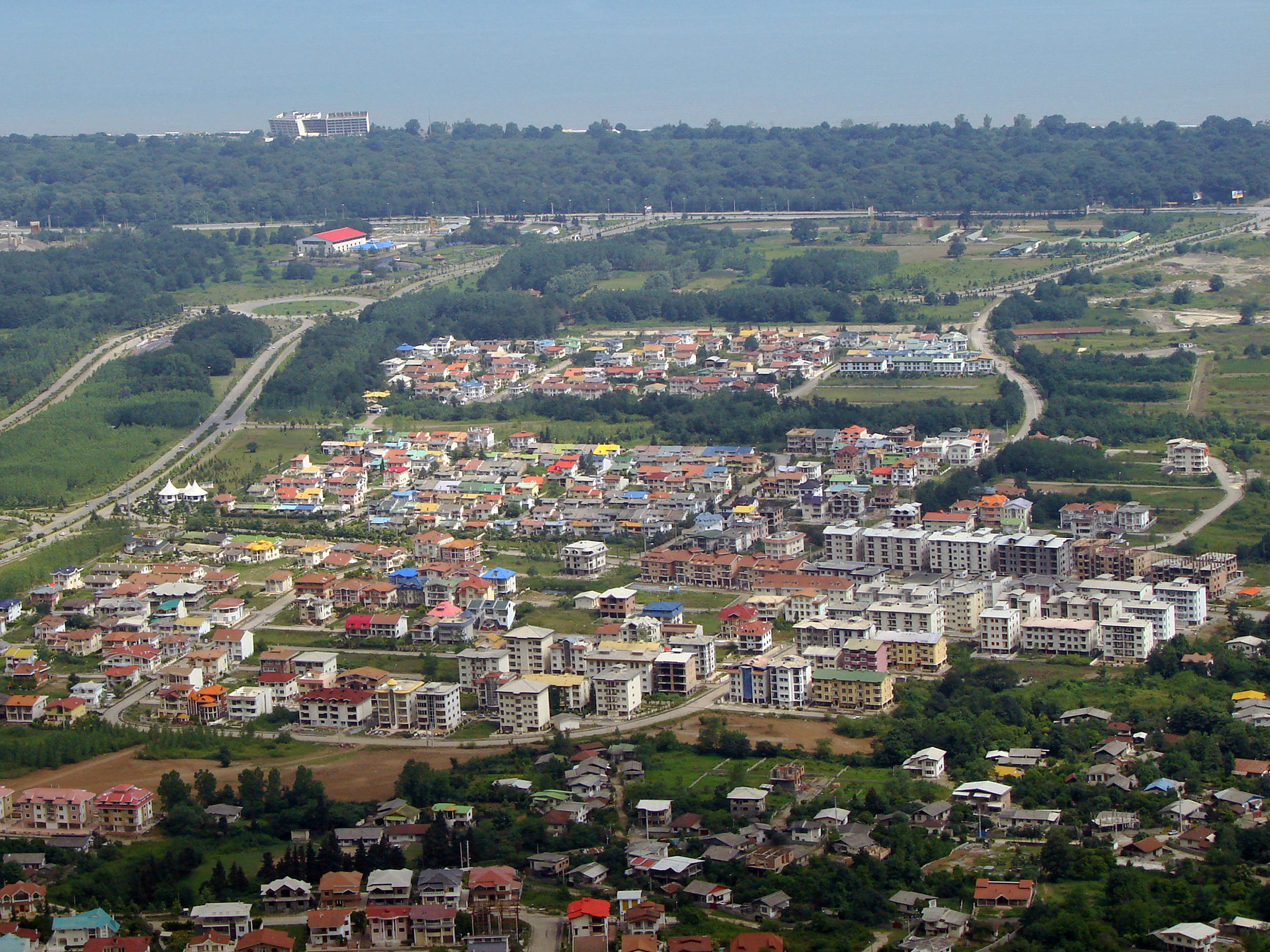
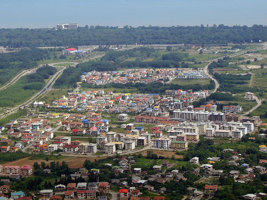
English: Shahrak-e Namak Abrud is a touristic village and has an aerial tramway which starts at the sea level near the shores of the Caspian Sea and ends on the top of the Alborz heights crossing dense forest area of northern Iran. There are numerous villa cities around it which form a vacation region for the people of Tehran.
فارسی: نمکآبرود شهرکی گردشگری و ویلایی است در استان مازندران ایران. این شهرک دارای دو خط تلهکابینی به نام تلهکابین نمکآبرود است.
شهرک نمک آبرود بین راه چالوس به تنکابن در ۱۲ کیلومتری چالوس قرار دارد.
Français : Namakabrood est situé à 12 km à l’est de Chalus et s’ettend sur une superficie de 650 hectares, avec la mer Caspienne au nord et Madoban (Alborz) au sud. Avec les parcs de violettes et la forêt dense de Madoban cette région offre des paysages splendides.
العربية: نمكآبرود (مقاطعة تشالوس) (بالإنجليزية: Shahrak-e Namak Abrud) هي مستوطنة تقع في Kelarestaq-e Gharbi Rural District في إيران.[1] يقدر عدد سكانها بـ 354 نسمة . |
| Usuku | |
| Umthombo | Own work |
| Umlobi | Mostafameraji |
| Camera location | | View this and other nearby images on: OpenStreetMap |
|---|
Licensing
I, the copyright holder of this work, hereby publish it under the following license:
This file is licensed under the Creative Commons Attribution-Share Alike 4.0 International license.
- Ukhululekile:
- ukwabelana – to copy, distribute and transmit the work
- to remix – to adapt the work
- Ngaphansi kwezimo ezilandelayo:
- attribution – You must give appropriate credit, provide a link to the license, and indicate if changes were made. You may do so in any reasonable manner, but not in any way that suggests the licensor endorses you or your use.
- yabelana ngokufana – If you remix, transform, or build upon the material, you must distribute your contributions under the same or compatible license as the original.
| Annotations | This image is annotated: View the annotations at Commons |
Umlando womqulu
Click on a date/time to view the file as it appeared at that time.
| Usuku/Isikhathi | Isithonjana | Dimensions | Umsebenzisi | Amazwana | |
|---|---|---|---|---|---|
| Njengamanje | 05:48, 8 uMasingana 2017 | | 3,000 × 2,250 (5.37 MB) | Mostafameraji | User created page with UploadWizard |
Ukusetshenziswa komqulu
The following page uses this file:
Ukusetshenziswa komqulu jikelele
Amanye ama-wiki asebenzisa lefayela
- Ukusetshenziswa ku-bg.wikipedia.org
- Ukusetshenziswa ku-en.wikibooks.org
- Ukusetshenziswa ku-fa.wikipedia.org
- Ukusetshenziswa ku-id.wikipedia.org
- Ukusetshenziswa ku-is.wikipedia.org
- Ukusetshenziswa ku-ko.wikipedia.org
- Ukusetshenziswa ku-la.wikipedia.org
- Ukusetshenziswa ku-lv.wikipedia.org
- Ukusetshenziswa ku-my.wikipedia.org
- Ukusetshenziswa ku-th.wikipedia.org
- Ukusetshenziswa ku-ur.wikipedia.org
- Ukusetshenziswa ku-vi.wikipedia.org
- Ukusetshenziswa ku-war.wikipedia.org
- Ukusetshenziswa ku-zh.wikipedia.org